
A Bright April Morning: The Adventure Begin
It’s a bright sunny day in April when my best friend Paulette and I set out in our small Suzuki SUV to explore the mighty Arenal Volcano.
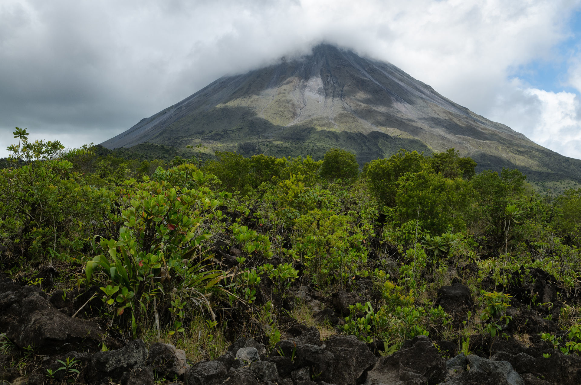
As we drove, memories flooded back to me. I remembered coming here many years ago as a young bride, with my Costa Rican husband. I could hardly believe my eyes back then—this giant creature of a volcano, spraying smoke and flaming lava from its summit, felt like something from another world. To me, it was truly one of God’s most beautiful creations.
Old School Memories & the Ring of Fire
Standing beneath the towering volcano, I turned to Paulette and asked,
“Do you remember our 9th-grade science teacher, Ms. Mary Bernace Carter?”
Ms. Carter—eccentric, wild grey hair, and a voice that demanded attention—used to frighten us with her predictions. She once told our class that an earthquake would push California straight into the ocean. Paulette confessed she didn’t sleep that night because her brother lived there.
But Ms. Carter also taught us something fascinating: that Arenal Volcano is part of the Ring of Fire—a horseshoe-shaped zone with nearly 450 volcanoes circling the Pacific Basin. Here, powerful tectonic plates constantly shift, generating tremors and occasional eruptions.
Suddenly, Paulette was looking at me uneasily when I said,
“We’re sleeping at the base of the volcano tonight.”
Sleeping Beneath a Giant: Arenal Observatory Lodge
That night, we stayed at the Arenal Observatory Lodge, a famous research base where scientists from the University of Costa Rica monitor volcanic activity.
Our cabin sat right at the foot of the volcano. It felt thrilling (and a little terrifying) to know that the massive giant was just outside our window.
Arenal had stopped erupting three years earlier, and locals now affectionately call it the Sleeping Giant.
No tremors.
No red-hot lava.
No fire shooting into the sky.
What a disappointment!
Still, there was something magical about being so close to such a powerful natural wonder.

Sky Tram, Sky Trek & Rainforest Wonders
The next morning, we woke at 5:30 am to a sky painted in hues of pink and blue. After breakfast, we headed to one of Arenal Volcano top attractions: Sky Tram & Sky Trek.
Sky Tram
Inside a glass gondola, we glided silently through the misty rainforest. The trees were alive with sound and color.
We spotted:
- Three howler monkeys with their baby
- A flock of toucans with their dramatically long, vibrant beaks
I couldn’t help but wonder:
“Why are their beaks sooo long? What a strange and beautiful bird.”
Sky Trek
Paulette mustered her courage and tackled the zip line—a platform soaring high above the rainforest canopy.
I met her at the bottom, and the smile on her face said it all:
pure joy.
Arenal’s Fiery Past
Arenal Volcano is often described as a “young” volcano—even though it’s roughly 7,500 years old.
For centuries, it lay dormant, covered in thick vegetation. But everything changed one August morning in 1968.
Farmers noticed something strange:
- The streams near the volcano were unusually warm
- Cattle huddled together
- Dogs barked relentlessly
Then, without warning—
A thunderous explosion shook the earth.
Huge circles of smoke rose from the summit.
Red-hot lava rocks rained down the mountainside.
The lava flowed north, destroying the village of Tabacón and killing 80 people. This eruption reshaped Arenal forever.
Birdwatching at Dawn & A Close Call
Today, Arenal Volcano is calm. Though we saw dark puffs drifting from the summit, no fiery explosions appeared.
Tourists still flock here—drawn by the volcano’s history and the hot mineral springs flowing from deep within the earth.
At 6 am, we joined a guided birdwatching tour. Within minutes, we spotted:
- Four pairs of toucans in a single tree
- A flock of squawking green parrots
- A black howler monkey with her baby, greeting us loudly
Suddenly our guide whispered urgently:
“Freeze.”
Right in our path, a small fer-de-lance snake—one of the most poisonous in Costa Rica—slithered across the trail. We stayed perfectly still until it disappeared into the brush.
Costa Ricans believe strongly in protecting their wildlife. Even venomous snakes play an important role in the ecosystem.
📍 General Location
Arenal Volcano National Park is in the San Carlos Valley of northern Costa Rica, near the small town of La Fortuna.
- Country: Costa Rica
- Province: Alajuela
- Nearest town: La Fortuna (about 6 km / 3.7 mi from the park entrance)
- Volcano name: Arenal Volcano
🗺️ How to Find It on a Map
If you’re using Google Maps, Apple Maps, Waze, etc., search for:
Arenal Volcano National Park, Costa Rica
This will take you to the main park entrance on:
➡️ Route 142 (Carretera 142) — the main road looping around Lake Arenal and connecting La Fortuna to Tilarán.
📌 Coordinates (if you use GPS or mapping apps)
- Latitude: 10.4630° N
- Longitude: -84.7030° W
You can enter these directly into Google Maps, a GPS device, or your phone’s map app.
🚗 Driving “Map Directions” from Key Points
From La Fortuna
- Start in the center of La Fortuna.
- Take Route 142 west/north toward Arenal Volcano National Park.
- Follow signs for about 6 km (≈ 4 miles).
- You’ll see the park entrance on the left side of the road.
🕒 Approx. drive time: ~15–20 minutes
📏 Distance: ~6 km / 3.7 mi
From San José (Central Valley)
- From San José/Alajuela, follow Inter-American Highway (Route 1) north.
- Near La Virgen de Sarapiquí, turn right onto Route 4.
- Continue to Route 35 north (around Los Chiles/Upala direction).
- Take Route 142 from Hola Vida / La Fortuna toward Arenal Volcano National Park.
🕒 Approx. drive time: ~3½ hours
🚗 Road type: Mostly paved highway
From Liberia (Northwest Costa Rica)
- Take Route 1 (Inter-American Highway / Pan-American) south toward Canas/Upala
- Sign onto Route 142 east toward Lake Arenal / La Fortuna
- Continue to Arenal Volcano National Park entrance
🕒 Approx. drive time: ~3 hours
📍 Best if flying into LIR (Daniel Oduber Quirós Intl Airport)
🧭 Key Reference Points Nearby
- La Fortuna Waterfall: ~6–8 km from park
- Lake Arenal: ~10–12 km west of the park
- Arenal Observatory Lodge: ~3–4 km up the same road
- Tabacón Hot Springs: ~10–12 km south along 142
- Mirador (volcano viewpoint): ~2–3 km inside the park entrance
🧭 What You See on the “Map”
When you look at the map of the area, you’ll notice:
Arenal Volcano National Park is roughly triangular:
- North edge: Lake Arenal
- East edge: Forest and private lands leading toward La Fortuna
- South edge: Agricultural lands and lodge areas
- West edge: Road (Route 142) circling toward Tilarán
The entrance to the park is on the south-west slope of the volcano.
📌 What to Look for on a Map
Major Features
- Arenal Volcano (Volcán Arenal) – large cone
- Arenal Volcano National Park – protected forest around the cone
- La Fortuna – town east of the volcano
- Lake Arenal – large reservoir north and west of the park
- Route 142 – semicircular road connecting everything
🚶♂️ Inside the Park
A typical walking trail map inside the park shows:
- Las Coladas Trail – old lava flow view
- Colada 1968 Viewpoint – best place to see the lava field from the 1968 eruption
- Vista Point Trail – classic volcano view
- Observation Point Trail – longest trail with views of rainforest and volcano
These are seen on detailed trail maps at the visitor center.
🗺️ How to Print a Map
If you want a physical or downloaded map, these are good sources:
- Google Maps:
Search: Arenal Volcano National Park - Costa Rica National Parks site
Look up: Arenal Volcano NP map - Tourism sites offering PDF trail maps (search:
“Arenal Volcano National Park trail map PDF Costa Rica”)
🧳 Pro Tip: Offline Maps
If you’re traveling without data:
- Use Google Maps offline
- Download the region around La Fortuna / Arenal
- Or use Maps.me with offline map download for Costa Rica
With GPS on your phone, you’ll still see your location even without cell service.
🧠 Visual Directions Summary
San José/Alajuela
        |
        | (Route 1 North)
        |
La Virgen → Route 4 → Route 35 → Route 142
        |                       ↘
        |                        Arenal Volcano NP
        |
     La Fortuna
Liberia
        |
Route 1 South
        |
Route 142 East
        |
Arenal Volcano NP